Geography
Location
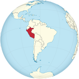
Western South America, bordering the South Pacific Ocean, between Chile and Ecuado
Geographic coordinates
10 00 S, 76 00 W
Map references
South America
Area
total: 1,285,216 sq km
land: 1,279,996 sq km
water: 5,220 sq km
Land boundaries
total: 7,062 km
border countries (5): Bolivia 1,212 km; Brazil 2,659 km; Chile 168 km; Colombia 1,494 km; Ecuador 1,529 km
Coastline
2,414 km
Climate
varies from tropical in east to dry desert in west; temperate to frigid in Andes
Terrain
western coastal plain (costa), high and rugged Andes in center (sierra), eastern lowland jungle of Amazon Basin (selva)
Elevation
highest point: Nevado Huascaran 6,746 m
lowest point: Pacific Ocean 0 m
mean elevation: 1,555 m
Natural resources
Copper, silver, gold, petroleum, timber, fish, iron ore, coal, phosphate, potash, hydropower, natural gas
Major lakes (area sq km)
Fresh water lake(s): Lago Titicaca (shared with Bolivia) - 8,030 sq km
Major rivers (by length in km)
Amazon river source (shared with Brazil [m]) - 6,400 km
note – [s] after country name indicates river source; [m] after country name indicates river mouth
Major watersheds (area sq km)
Atlantic Ocean drainage: Amazon (6,145,186 sq km)
Major aquifers
Amazon Basin
Population distribution
Approximately one-third of the population resides along the desert coastal belt in the west, with a strong focus on the capital city of Lima; the Andean highlands, or sierra, which is strongly identified with the country's Amerindian population, contains roughly half of the overall population; the eastern slopes of the Andes, and adjoining rainforest, are sparsely populated
Natural hazards
Earthquakes, tsunamis, flooding, landslides, mild volcanic activity
Volcanism: volcanic activity in the Andes Mountains; Ubinas (5,672 m), which last erupted in 2009, is the country's most active volcano; other historically active volcanoes include El Misti, Huaynaputina, Sabancaya, and Yucamane; see note 2 under
Geography - note
note 1: shares control of Lago Titicaca, world's highest navigable lake, with Bolivia; a remote slope of Nevado Mismi, a 5,316 m peak, is the ultimate source of the Amazon River
note 2: Peru is one of the countries along the Ring of Fire, a belt of active volcanoes and earthquake epicenters bordering the Pacific Ocean; up to 90% of the world's earthquakes and some 75% of the world's volcanoes occur within the Ring of Fire
note 3: on 19 February 1600, Mount Huaynaputina in the southern Peruvian Andes erupted in the largest volcanic explosion in South America in historical times; intermittent eruptions lasted until 5 March 1600 and pumped an estimated 16 to 32 million metric tons of particulates into the atmosphere reducing the amount of sunlight reaching the earth's surface and affecting weather worldwide; over the next two and a half years, millions died around the globe in famines from bitterly cold winters, cool summers, and the loss of crops and animals
note 4: the southern regions of Peru and the extreme northwestern part of Bolivia are considered to be the place of origin for the common potato
People and Society
Population
32,275,736 (2022 est.)
country comparison to the world: 45
Ethnic groups
Mestizo (mixed Amerindian and White) 60.2%, Amerindian 25.8%, White 5.9%, African descent 3.6%, other (includes Chinese and Japanese descent) 1.2%, unspecified 3.3% (2017 est.)
Languages
Spanish (official) 82.9%, Quechua (official) 13.6%, Aymara (official) 1.6%, Ashaninka 0.3%, other native languages (includes a large number of minor Amazonian languages) 0.8%, other (includes foreign languages and sign language) 0.2%, none 0.1%, unspecified 0.7% (2017 est.)
Religions
Roman Catholic 60%, Christian 14.6% (includes Evangelical 11.1%, other 3.5%), other 0.3%, none 4%, unspecified 21.1% (2017 est.)
Climate
varies from tropical in east to dry desert in west; temperate to frigid in Andes
Major lakes (area sq km)
Fresh water lake(s): Lago Titicaca (shared with Bolivia) - 8,030 sq km
Major rivers (by length in km)
Amazon river source (shared with Brazil [m]) - 6,400 km
note – [s] after country name indicates river source; [m] after country name indicates river mouth
Etymologycountry name: Exact meaning is obscure, but the name may derive from a native word "biru" meaning "river"